
Yildirim Okta, Birge  ORCID: https://orcid.org/0000-0001-7872-2239, Okta, Gurkan and Sohtorik Sokmenoglu, Ahu
(2026)
Landscape-Led Planning for Fire-Resilient Territories: Artist Residencies and Art Campus Development.
[Data Collection]
ORCID: https://orcid.org/0000-0001-7872-2239, Okta, Gurkan and Sohtorik Sokmenoglu, Ahu
(2026)
Landscape-Led Planning for Fire-Resilient Territories: Artist Residencies and Art Campus Development.
[Data Collection]
Abstract
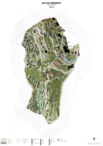
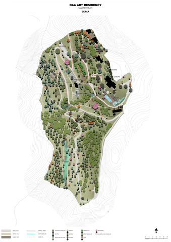
The study proposes landscape-led strategies to strengthen territorial resilience through fire-adaptive spatial design, water protection and retention, and the restoration and enhancement of wildlife habitats. Over six months, it maps ecological networks, hydrological systems, and wildland–urban interfaces, translating findings into site-specific planning principles and design guidelines for an emerging art campus and residency programme. Supported by a £9,000 award, the project delivers practical tools for climate adaptation, land stewardship, and regenerative place-making in fire-prone Mediterranean landscapes.
| Additional Information: | Depositing user's licence comment: | ||||
|---|---|---|---|---|---|
| Creators: | Yildirim Okta, Birge ORCID: https://orcid.org/0000-0001-7872-2239, Okta, Gurkan and Sohtorik Sokmenoglu, Ahu |
||||
| Uncontrolled Keywords: | Fire-Resilient Landscape Planning; watershed protection; ecological resilience; nature-based solutions; artist residency infrastructure; 410102 Ecological impacts of climate change and ecological adaptation; 330109 Landscape architecture | ||||
| DOI: | https://doi.org/10.24377/LJMU.d.00000255 | ||||
| Division: | Art & Design | ||||
| Field of Research: | Built environment and design > Architecture > Landscape architecture Environmental sciences > Climate change impacts and adaptation > Ecological impacts of climate change and ecological adaptation |
||||
| Date Deposited: | 09 Feb 2026 09:08 | ||||
| Last Modified: | 09 Feb 2026 09:08 | ||||
| URI: | https://opendata.ljmu.ac.uk/id/eprint/255 | ||||
| Data collection method: | Data were collected through a mixed-method approach combining GIS-based spatial mapping, remote sensing and satellite image review, and on-site field surveys documenting vegetation structure, habitat conditions, hydrological features, and fire-related vulnerabilities. These observations were supported by photographic recording (and drone imagery where available), desk-based review of planning documents and environmental reports, and stakeholder engagement through semi-structured interviews and co-design workshops to translate ecological and water-sensitive findings into practical planning and design guidelines. | ||||
| Resource language: | Turkish | ||||
| Metadata language: | English | ||||
| Collection period: |
|
Download
![[img]](https://opendata.ljmu.ac.uk/id/eprint/255/1/250205_OKTAA_DAA_ARTRESIDENCYMASTERPLAN_SATURASYON.jpg)
 Preview |
![[img]](https://opendata.ljmu.ac.uk/style/images/fileicons/text.png)
![[img]](https://opendata.ljmu.ac.uk/style/images/fileicons/archive.png)
Explore Further
Read more research from the creator(s):
Find work funded by this grant:
Actions (Log-in required)
 View Item